A research voyage aimed at shedding light on Macquarie Island’s underlying structure and geological evolution, while also enabling monitoring of future earthquakes and tsunamis that could affect Australia and New Zealand, will this week sail from Hobart.
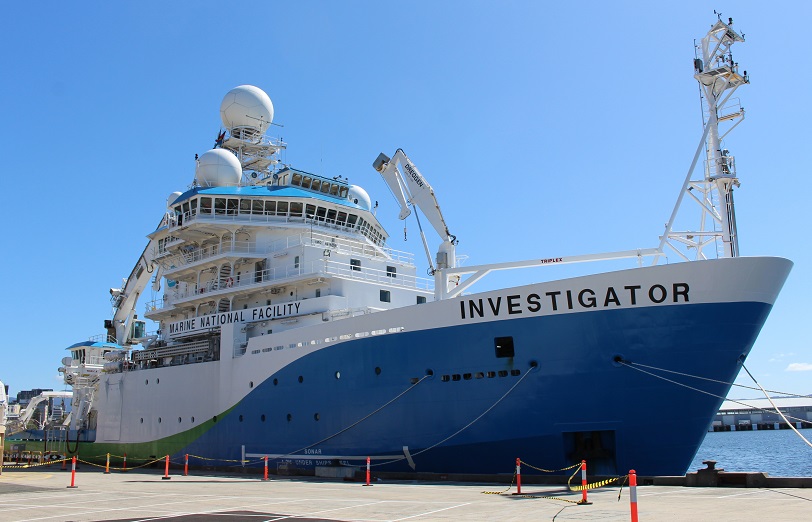
Led by IMAS Professor Mike Coffin and including scientists from ANU, the voyage on Australia’s national research vessel RV Investigator, owned and operated by CSIRO, will allow researchers to produce the first high-resolution maps of the seafloor surrounding Macquarie Island, much of it lying within the island’s Nature Reserve and Macquarie Island Marine Park.
At the same time, ANU scientists led by Professor Hrvoje Tkalčić will deploy seismometers on the seafloor around the island to allow them to investigate the region’s crustal and mantle structure as well as its seismicity.
Professor Coffin said Macquarie Island sits on the highly active tectonic plate boundary between the Australian and Pacific plates and generates some of the largest intra-oceanic earthquakes away from subduction zones.
“The creation of seafloor maps identifying faults, fracture zones, and relict seafloor spreading centres will yield insights into the structure, behaviour, and history of this important plate boundary, which presents significant tsunami hazards for both sides of the Tasman Sea,” Professor Coffin said.
“The maps will also shed light on why and how Macquarie Island, which formed around 2500 metres below sea level, was thrust above sea level.
“World Heritage-listed because of its unique geological exposures of both crustal and mantle rocks, the island hosts Australia’s only sub-Antarctic research station, which includes a seismometer,” Professor Coffin said.
Professor Tkalčić said the 29 seismometers to be deployed on the seafloor will be recovered in late 2021 or early 2022, returning data critical for addressing the project’s seismological objectives.
“Our research has two main aims: first, to image Earth structure by utilising state-of-the-art seismological techniques in conjunction with a carefully designed configuration of ocean bottom seismometers pointing towards the Earth’s centre like a giant antenna; second, to elucidate the physics of the world’s largest underwater earthquakes not associated with active subduction.”
“Such a remote and unique location chosen for our experiment will also improve the spatial coverage of the Earth’s deepest interior by seismic waves of distant earthquakes recorded by our seismometer array, and enable a range of geophysical studies, including interactions of the ocean and atmosphere with the solid Earth,” Professor Tkalčić said.
RV Investigator leaves Hobart on Friday 9 October and is scheduled to return on Sunday 1 November.
Weekly Report #4 (26 October – 2 November) – IN2020_V06 – Chief Scientist Prof Mike Coffin
The Furious Fifties are now in our wake as we traverse the Roaring Forties, and we’re on schedule to dock in Hobart at 0800 on 3 November. The passage of time seemed to accelerate as we completed our final week at sea, which proved highly productive. We mapped yet more seafloor around Macquarie Island and finished deploying the final 11 of our total 27 ocean bottom seismometers (OBSs). We departed the study area and commenced the transit to Hobart late in the evening on 30 October.
Atrocious weather was a hallmark of this voyage. Starting with heavy weather the night we departed Hobart, delaying our arrival in the work area, we experienced the most sustained foul weather of any of my 14 Southern Ocean voyages that now encompass 500+ days in these tempestuous latitudes. RV Investigator was compelled to either heave to or seek shelter behind Macquarie Island on 12 of our 19 days in the study area, and we lost a total of 7.5 of our 19 days, or 38%, there due to weather. This does not include time lost to heavy seas forcing us to reduce speed on both our mapping lines and our transits between OBS deployment sites. Fortunately, we were granted two additional days of sea time that partially offset the time lost waiting on weather. And RV Investigator proved once again to be the highly capable, multi-purpose, dedicated research platform that Australia needs to enable researchers to address Australia’s most pressing marine scientific challenges of high societal relevance.
As we approach the end of the voyage, we are devoting substantial effort to preparing various reports. We are working on a Voyage Scientific Highlights & Summary, a Chief Scientist Operational Report, and metadata forms. And our research permits from Parks Australia and the Tasmania Parks & Wildlife Service obligate us to document and report any lost equipment – in our case two OBSs – and make bathymetric maps of the Macquarie Island Marine Park and Macquarie Island Nature Reserve, respectively.
 During the transit, the science party was occupied with packing the OBS container, finalizing shipboard data and metadata compilations, and synthesizing initial results. Demobilisation should be completed the day of our arrival.
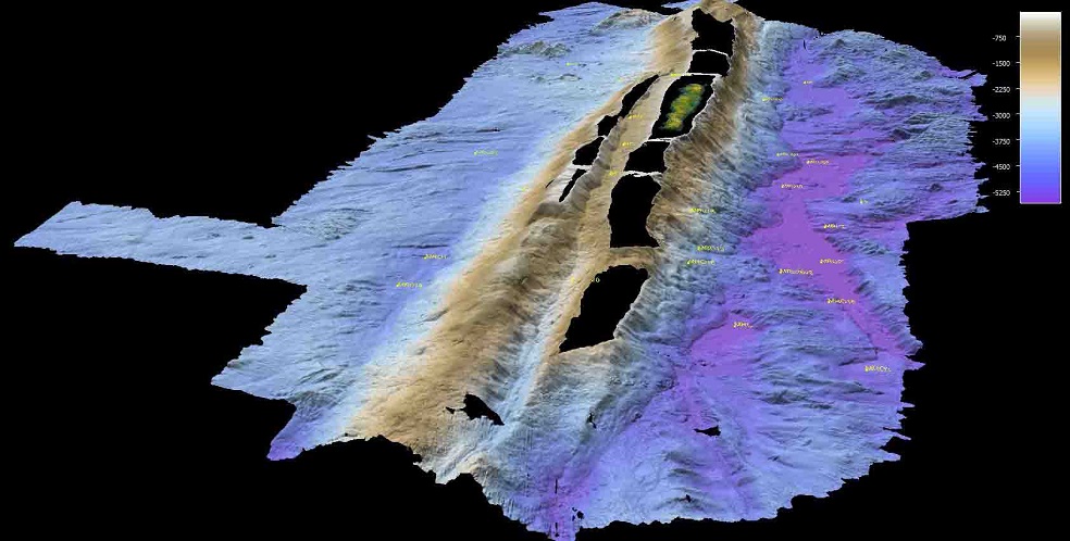
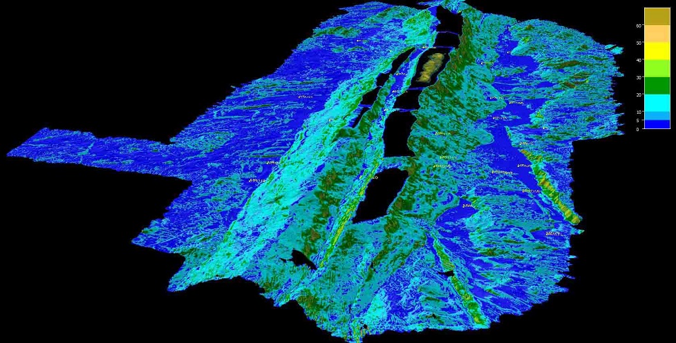
(Images, right: maps showing multibeam echosounder data acquired during IN2020_V06 and derivatives, with Macquarie Island (top center), OBS deployment sites (yellow), and unmapped areas (black) indicated. Upper: bathymetry. Middle: slope. Lower: backscatter)
Poignant reunions with family and friends will have to wait for our Canberra-based contingent of nine; only two of us reside in Hobart.
Planning, executing, and supporting IN2020_V01 involved not only the 40 voyage participants, but also many, many people ashore, especially the two other principal investigators on the research project, Prof 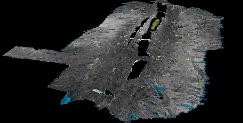 Nick Rawlinson of the University of Cambridge and Prof Joann Stock of the California Institute of Technology. The support of family and friends of the shipboard complement was much appreciated, and we are extremely grateful to everyone for their extraordinary contributions to the success of the voyage!
Here’s to a healthy and happy summer and year ahead…and to copious large, but non-destructive earthquakes around the world for the OBSs to record!
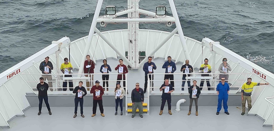
(Image, below: Scientists, students, and support staff on the bow of RV Investigator, 2 November 2020. MCQ3D: Macquarie Ridge in 3-D. Credit: Kristian Webster, ASP)
 The 1,600-km-long Macquarie Ridge Complex is the non-fiery, southwesternmost segment of the 40,000-km-long “Ring of Fire” bordering much of the Pacific Ocean basin. The Ring of Fire is a nearly continuous series of oceanic trenches, volcanic arcs, volcanic belts, and intervening transform faults, the first three manifestations of tectonic plate subduction, and the last indicating strike-slip motion between tectonic plates.
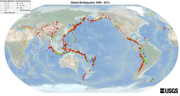
(Image, right: The Pacific “Ring of Fire” as outlined by earthquakes Mw >7.0 (1900-2013). Circle sizes indicate magnitude, and colors indicate their depth. Yellow triangles are active volcanoes. Credit: US Geological Survey)
 The Ring of Fire is responsible for 90% of the world’s earthquakes and 81% of the world’s largest earthquakes. In the past 11,700 years, 88% of the worlds largest volcanic eruptions have occurred along the Ring of Fire. Along the Ring of Fire, the Macquarie Ridge Complex appears to be unique. Why, because changing relative motion between the Pacific and Australian plates appears to be initiating subduction of the Australian plate beneath the Pacific plate at the Ridge’s northern (Puysegur) and southern (Hjort) ends. And between these two segments lie the McDougall (northern) and Macquarie (southern) segments – the latter the focus of our research – where transpression along the plate boundary has produced their respective ridges (west) and troughs (east).
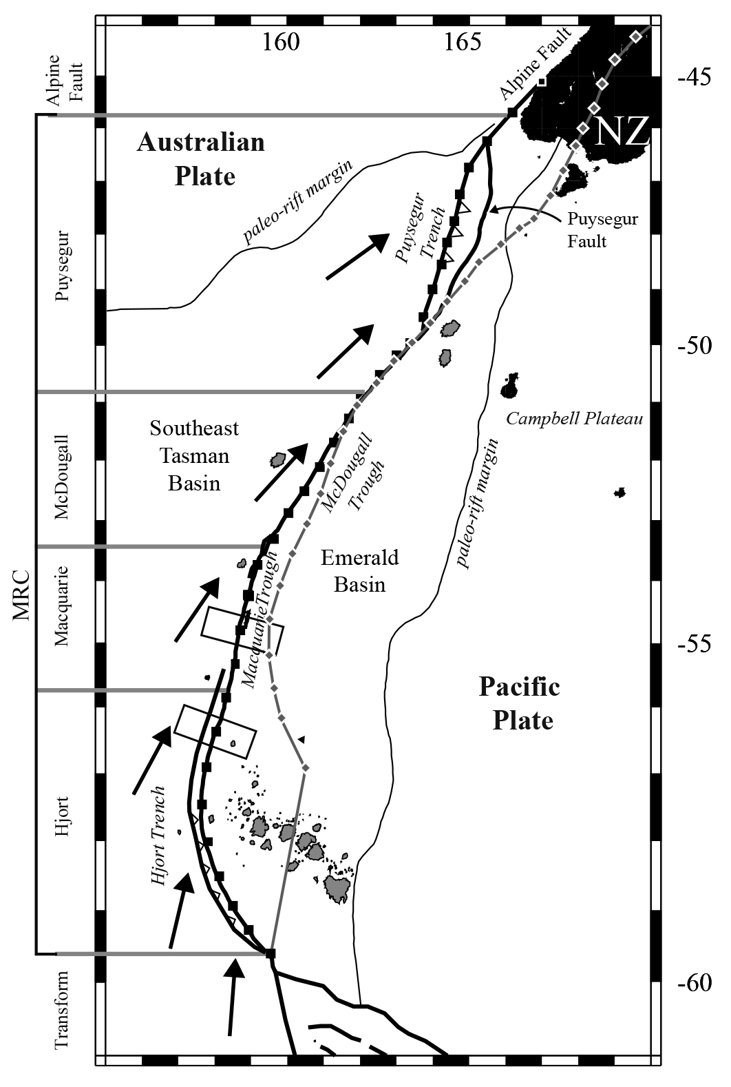
(Figure, left: Physiography of the Macquarie Ridge Complex. Alpine Fault, Puysegur, McDougall, Macquarie, and Hjort distinctions indicated. Solid lines are the convergent and strike-slip plate boundary fault zones. Arrows indicate approximate direction of relative convergence at the plate boundary zones. Gray features with black outlines are volcanoes. Credit: modified from Tip Meckel)
Since arriving at the study area surrounding Macquarie Island on 11 October, we have mapped the seafloor at high resolution to the northeast, southeast, and southwest of the island, but have considerable remaining areas to map along the crest of the entire Macquarie Ridge segment and to the northwest of Macquarie Island. The new mapping data are revealing much about the history of seafloor spreading that created the crust of the entire Macquarie Ridge Complex, as well as illuminating the deformation of that crust since seafloor spreading ceased.
 Furthermore, the new mapping data have enabled identification of locations to deploy 16 ocean bottom seismometers (OBSs) and to plan deployment of five more. Five additional OBS deployment locations to the northwest and northeast of Macquarie Island await identification from to-be-acquired mapping data. Another OBS was lost this past week in addition to one lost the previous week. This week’s loss is a mystery; we don’t know if the OBS made it to the bottom, as when we last communicated with and located it, it was stuck at ~2400 m water depth, unable to ascend (or descend). Where deployed, water depths were >5000 m. As with the previous lost instrument, this one will be carried eastward around Antarctica by the Antarctic Circumpolar Current.
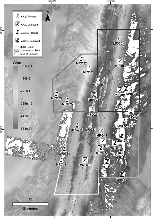
(Figure, right: Map of Macquarie Island region showing locations, both deployed and planned, of OBSs. Credit: Yun Fann Toh)
Every day at 1300 the voyage’s senior management team – Master Michael Watson, Voyage Manager Megan Hartog, and I – meet, together with other key leaders, for about 30 minutes to discuss plans for the next 24-48 hours and any other matters of import. Communication is also frequent throughout the day. Organising, managing, and coordinating our respective teams is critical for effectiveness and efficiency as we conduct our operations in the dynamic and often challenging environmental conditions.
 Many who aren’t on watch congregate at 1400 for our near-daily seminar series, at which anyone can speak on a topic relevant to our research program or of general interest. To date, nine seminars have been presented by members of the science party, support team, and ship’s crew. In addition to sharing expertise and knowledge with anyone who’s interested, the seminars stimulate conversation, give everyone and especially students the opportunity to hone their presentation skills, and foster team building among our disparate personalities, skill sets, nationalities, and ages. Two personnel aboard the ship, Aaron Tyndall and I, have previously worked on Macquarie Island, and have shared our experiences in recent seminars.
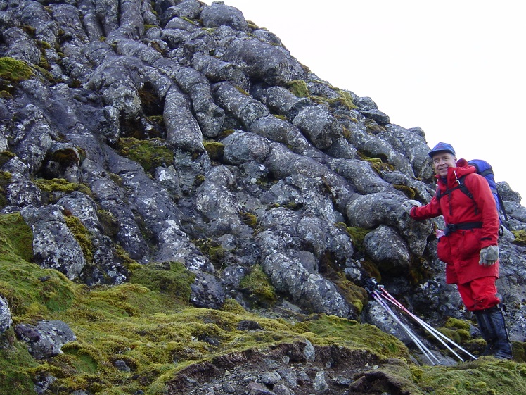
(Image, above: Pillow basalts of “Spaghetti Hill,” Macquarie Island, with myself for scale. Credit: Nathan Daczko)
 20 October 2020 - Yun Fann Toh
“Hi Fann, Good news – you’re now confirmed on IN2020_V06, so block out your calendar.” - Prof Mike Coffin, 7/7/2020
Amidst the COVID pandemic, that e-mail endorsed my second voyage aboard RV Investigator. We departed on a cloudy Thursday afternoon, 8th of October, from Hobart. Of course, this was only authorised after all voyage personnel had undergone an invasive swab test to detect for the corona virus (I could expand on that, but I had an embarrassing sneezing fit accompanied by a face full of tears – so let’s leave it at that). Isolation was later mandatory as we awaited our results.
 After a couple of days, Macquarie Island was finally in sight! Also, considering the time of the year, of course the weather was bad! While more than half of the science party remained bedridden from seasickness, overcast weather and choppy seas greeted the remaining crew. Little did we know – that land would be our shelter for many days to come.
Still, the vessel pushed on and the GSM (geophysical survey and mapping) team worked hard in getting the NE flank of Macquarie Ridge mapped. Thanks to Phil and Cisco, I had the opportunity to learn what goes on behind the scenes. Though short (social distancing prevents different cohorts from interacting for more than 15 minutes), I was able to observe and learn how various data were acquired real-time and processed.
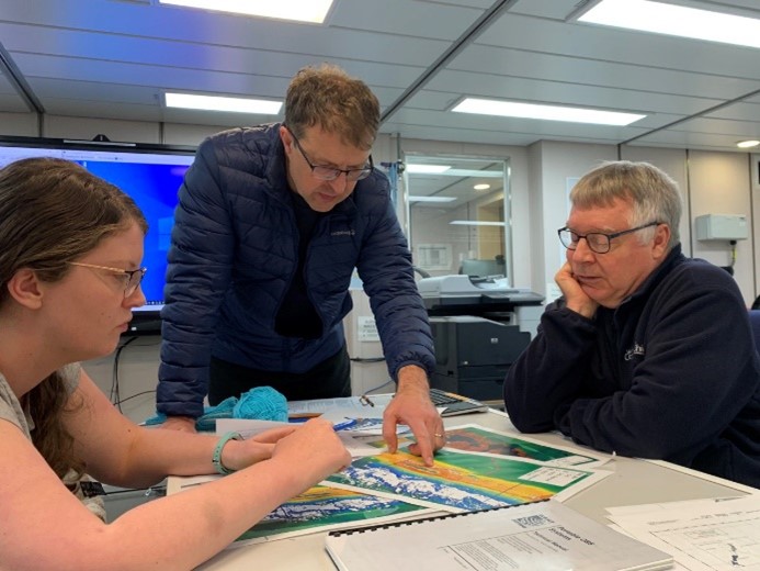
 Now, being a mere Honours student amongst reputable scientists and technicians, I thought the trip would have been incredibly daunting. No fooling around. No dancing. No letting loose. Naturally, my over thinking got ahead of me yet again. Everyone is in fact kind and very accommodating – especially with regard to my need (NEED!!!) for sleep. Though, despite my occasion tardiness for my 2am to 2pm shift, I do give my all towards the things I am tasked to do. This includes working with the GSM team to produce maps for the analysis and selection of sites for OBS deployment. Furthermore, by working in the same cohort as Dr Caroline Eakin and Prof Mike Coffin (pictured, below, discussing OBS deployment with Professor Hrvoje Tkalčić), I am given the opportunity to pick up various things outside of my degree. Cheers to the 2 pm science seminars.
 Well, besides the science and learning, food is amaZING this trip. Much love to both caterers, Emma and Alan, as well to the chefs, Chris and Kane. They surely have one of - and if not - the toughest job on this ship. My wellbeing and essential needs have surely been well taken care of by them. Such a privilege to not have to worry about what to cook at the end of the day. And THE DESSERTS. Oh lord, my palate is blessed and pampered.
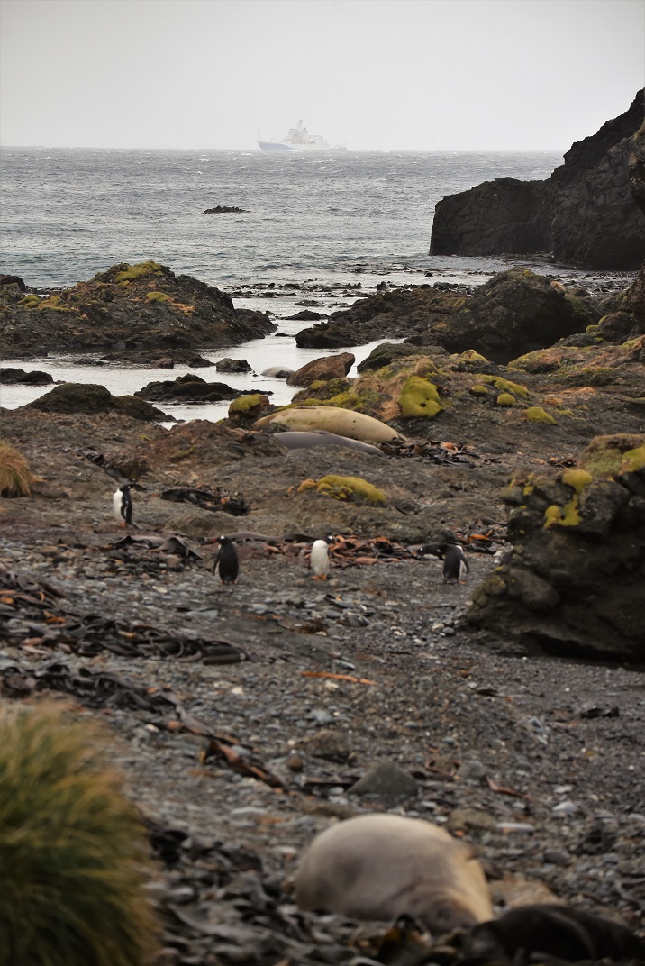
Presently, the ship is once again hiding behind the majestic island. Winds continue to rage across Macquarie Ridge, agitating the waves beneath. Though, on occasional cold mornings, the ship’s deck has been covered in ice as the adjacent island coloured in white. The ever-changing landscape also awes most of the crew (I say ‘most of’ because some hate the choppiness HAHAHA) and sometimes offers pleasant sightings of penguins, orcas, seals, and aurora australis.
Here’s to smooth sailing for the remaining voyage and good weather conditions for the deployment of 26 more OBSs.
p.s. Shout out to the first team I have ever worked with on my first ever voyage, IN2020_V01! They have been the ones that made my trip memorable and inspired me to join future voyages: Sylvie, Christoff, Sascha, Luca, and Dongdong (Hanuman you too), hope you are all doing well! Also, to the crew of IN2020_V01, missing you guys across the Southern Ocean.
 Weekly Report #2 (12-18 October 2020) – IN2020_V06 – Chief Scientist Professor Mike Coffin
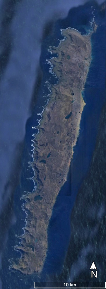
Macquarie Island, the centre of our mapping efforts and ocean bottom seismometer (OBS) deployments, is a UNESCO World Heritage Site. Macca, as it is commonly known, is the only island in the world composed entirely of oceanic crust and rocks from the mantle. The 34-km-long by 5-km-wide island is also the only subaerial exposure of the Macquarie Ridge Complex, a ~1,600-km-long undersea mountain range that marks the boundary between the Australian and Pacific tectonic plates. We are working here because we want to understand why this plate boundary generates extremely large (Mw 8+) earthquakes, the largest in the oceans not related to tectonic plate subduction.
(Google Earth satellite image, right, of Macquarie Island. Credit: Scripps Institute of Oceanography, US National Oceanic and Atmospheric Administration, US Navy, US National Geospatial-Intelligence Agency, General Bathymetric Chart of the Oceans, Lamont-Doherty Earth Observatory of Columbia University, US National Science Foundation, Centre national d’études spatiales/Airbus)
If all of Macquarie Ridge were above sea level, it would be the steepest and narrowest mountain range on the planet, with ~6,000 m of relief from its base to the highest point (433 m) on Macca. By comparison, reliefs and widths from base level of two of the world’s major mountain ranges pale in comparison: the Himalayas have a maximum relief of ~3,700 m, and are ~150-350 km wide, and the Andes have a maximum relief of ~2,600 m, and are ~500 km wide. Macquarie Ridge’s extreme relief, combined with lying directly in the path of the ocean’s most powerful current – the Antarctic Circumpolar Current (ACC) – makes site selection and ocean bottom seismometer (OBS) deployments exceptionally challenging, more so than at any other location in the global ocean.
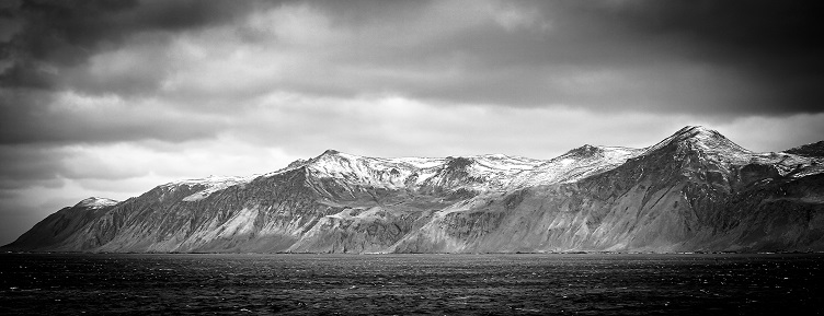 We sheltered on Macca’s proximal lee (eastern) side for all or part of six days this week, high seas and winds preventing us from both mapping the seafloor and deploying OBSs where needed. Island climate is harsh; the Bureau of Meteorology reports the following mean October values: temperature–3.9°C, clear days–0.3, cloudy days–24.1, and wind speed–36.5 km/hr (20 kts). Wind gusts exceeding 170 km/hr (92 kts) have been recorded. We experienced winds exceeding 115 km/hr (62 kts) and waves of 6-7 m during the week. The Furious Fifties are living up to their moniker.
(Image, above: A brisk spring day sheltering in the lee of Macca. Credit: Hugh Barker, CSIRO)
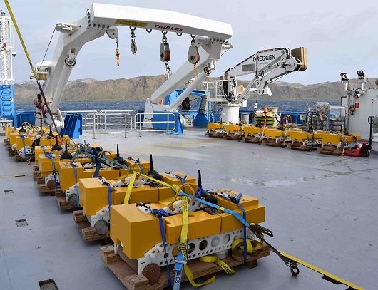
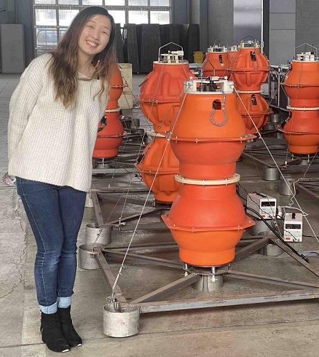 We are deploying two types of OBSs on this voyage, a pool of 17 that is part the Australian National Seismic Imaging Resource/AuScope (aka AGOS), and 12 hired from the Institute of Geology & Geophysics, Chinese Academy of Sciences (aka CAS). Although the two types of instruments will record the same global earthquakes over the next year, they differ markedly in design.
(Images, above: AGOS (right) and CAS OBSs (left), with IMAS Honours student and IN2020_V06 Science Party member Yun Fann Toh. Credits: Max McGuire, CSIRO (AGOS); Mike Coffin (CAS))
Despite the inclement weather this week, we were able to deploy one AGOS and five CAS instruments to the northeast and west of Macca. Unfortunately, one CAS instrument resurfaced after being deployed, and despite the valiant efforts of RV Investigator’s master and crew, eluded recovery and is now riding the ACC toward the Drake Passage between Patagonia and the Antarctic Peninsula. We thus have 23 OBSs remaining to deploy.
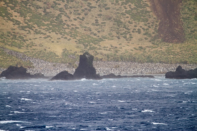 Discovered in 1810 by sealers, Macca is renowned for its inhospitality. Captain Douglass, the master of the Sydney vessel Mariner, visited the island in 1822, and wrote “it is the most wretched place of involuntary and slavish exilium that can possibly be conceived: nothing could warrant any civilized creature living on such a spot…” Sealing lasted from 1810 to 1919, during which seals and penguins were hunted to near-extinction. Populations of seals (fur, elephant) and penguins (gentoo, king, rockhopper, royal) have since rebounded, e.g., >9,000 elephant seal females, and an estimated 3,000,000 pairs of royal and 200,000 pairs of king penguins. make Macca their home. And after eradication of invasive pests, Macca was declared free of cats, rats, rabbits, and mice in 2014.
(Image, above: Penguin colony on Macquarie Island. Credit: Hugh Barker, CSIRO)
Macca hosts Australia’s only sub-Antarctic research station. The Australian National Antarctic Research Expedition (ANARE) station, managed by the Australian Antarctic Division (AAD), was established in 1948, and lies approximately halfway between mainland Australia and Antarctica. Most station expeditioners arrived in October 2019 to spend an entire year on Macca, and a personnel changeover had been planned for this month. However, due to COVID-19 complications, the changeover has been rescheduled for March 2021.
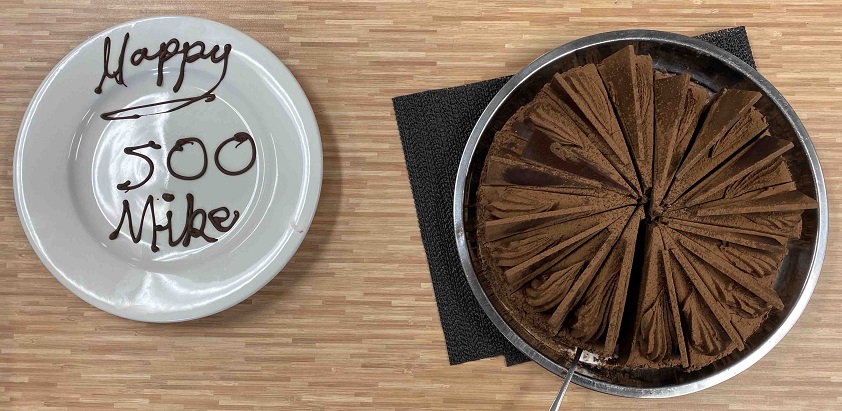 Closing on a personal note, 18 October marked my 500th day, encompassing 14 voyages, on research vessels in the Southern Ocean, a journey that started in 1985 on an expedition to the Heard Island region. Most unexpectedly and gratifyingly, the galley team – Alan, Chris, Emma, & Kane – commemorated the occasion with a scrumptious chocolate dessert – heartfelt thanks to them and the rest of my shipmates!
(Image, right: Chocoholic masterpiece created for my 500th day on the Southern Ocean! Credit: Mike Coffin)
 RV Investigator voyage IN2020_V06 – Probing the Australian-Pacific Plate Boundary: Macquarie Ridge in 3-D – departed Hobart, Tasmania, on Thursday 8 October, bound for the Macquarie Island region, Southern Ocean, on a nominal 24-day mission. The overarching objectives of the voyage are to:
(Image, above, right: RV Investigator from Garden Cove on Macquarie Island. Credit William Seal, AAD)
The alternate Chief Scientist on this voyage, Prof Hrvoje Tkalčić of the Australian National University (ANU), initiated development of the project in 2015, and in the intervening five years, he, Prof Nick Rawlinson (University of Cambridge; formerly of ANU), Prof Joann Stock (California Institute of Technology), and I have assembled a international team of seismology and marine geophysics researchers and students, submitted multiple applications to various agencies and authorities for support and permissions, been granted ship time and science funding, and obtained requisite environmental permits. Thus the voyage is the culmination of considerable effort and planning involving scores of people from around the world.
 Unfortunately, COVID-19 protocols have not allowed any of the international principal investigators, their students, and their technicians to join the voyage. However, trial virtual participation has been implemented for the first time on RV Investigator; for example, Prof Stock is my off-side marine geophysicist on the opposite 12-hour watch, joining the voyage remotely from Pasadena, California, USA.
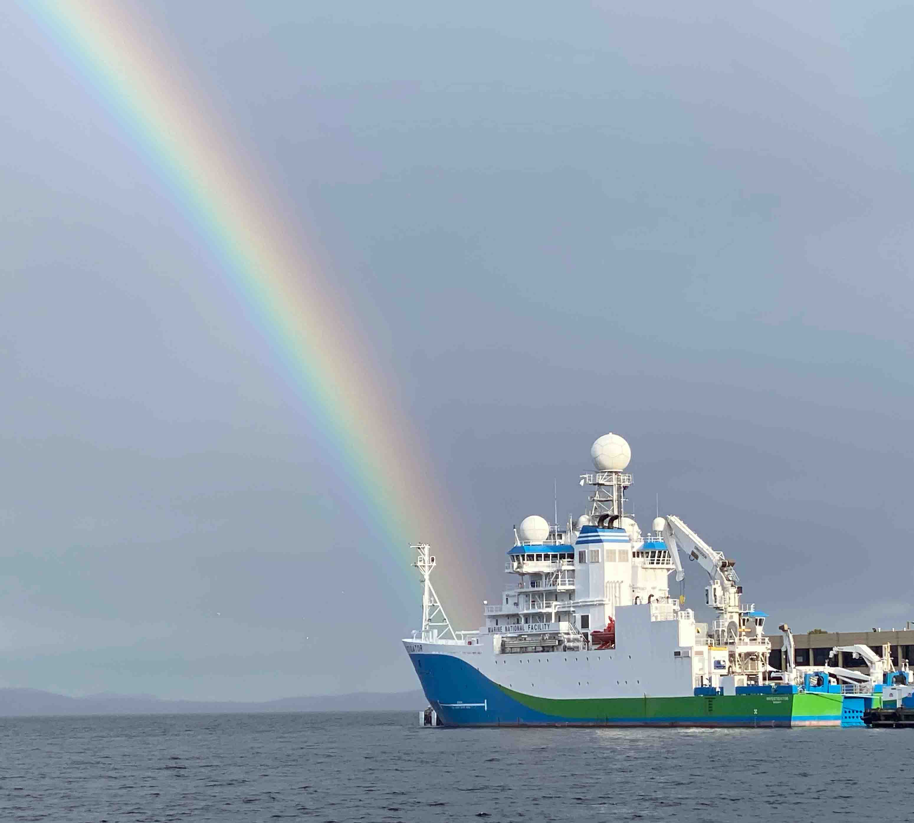
(Image, left: RV Investigator at the end of the rainbow, 24 September 2020. Credit: Mike Coffin)
Mobilisation activities involving the OBSs commenced in early 2020 for the original voyage dates of 24 March-18 April. Since the start of the year, the instruments have been prepared and shipped from their landlocked home ports of Canberra (Australian Geophysical Observing System, or AGOS) and Beijing (Institute of Geology & Geophysics, Chinese Academy of Sciences, or IGGCAS) to Hobart.
The shipboard science party began arriving in Hobart for voyage mobilisation in mid-September, with the nine ANU personnel undergoing a mandatory 14-day quarantine commencing upon arrival in Tasmania. Shore-based unpacking, assembling, testing, charging, and calibration of the OBSs commenced on 23 September and continued through 5 October. The entire science party first convened for inductions on 5 October, and the OBSs were loaded onto RV Investigator on 5 and 6 October. On the morning of 6 October, all 40 people joining the voyage were tested for COVID-19, and then went into isolation aboard the docked ship awaiting test results. All results returned negative the morning of 8 October.
 We number 40 souls on this voyage. That total includes 11 members of the science party, nine science technical staff, and 20 ship’s crew. The 20-strong research team is a mini-United Nations, with 13 nationalities from all six inhabited continents represented. This diversity reflects our efforts to assemble the best scientific team globally to achieve our research objectives as well as the boundless nature of the global ocean.
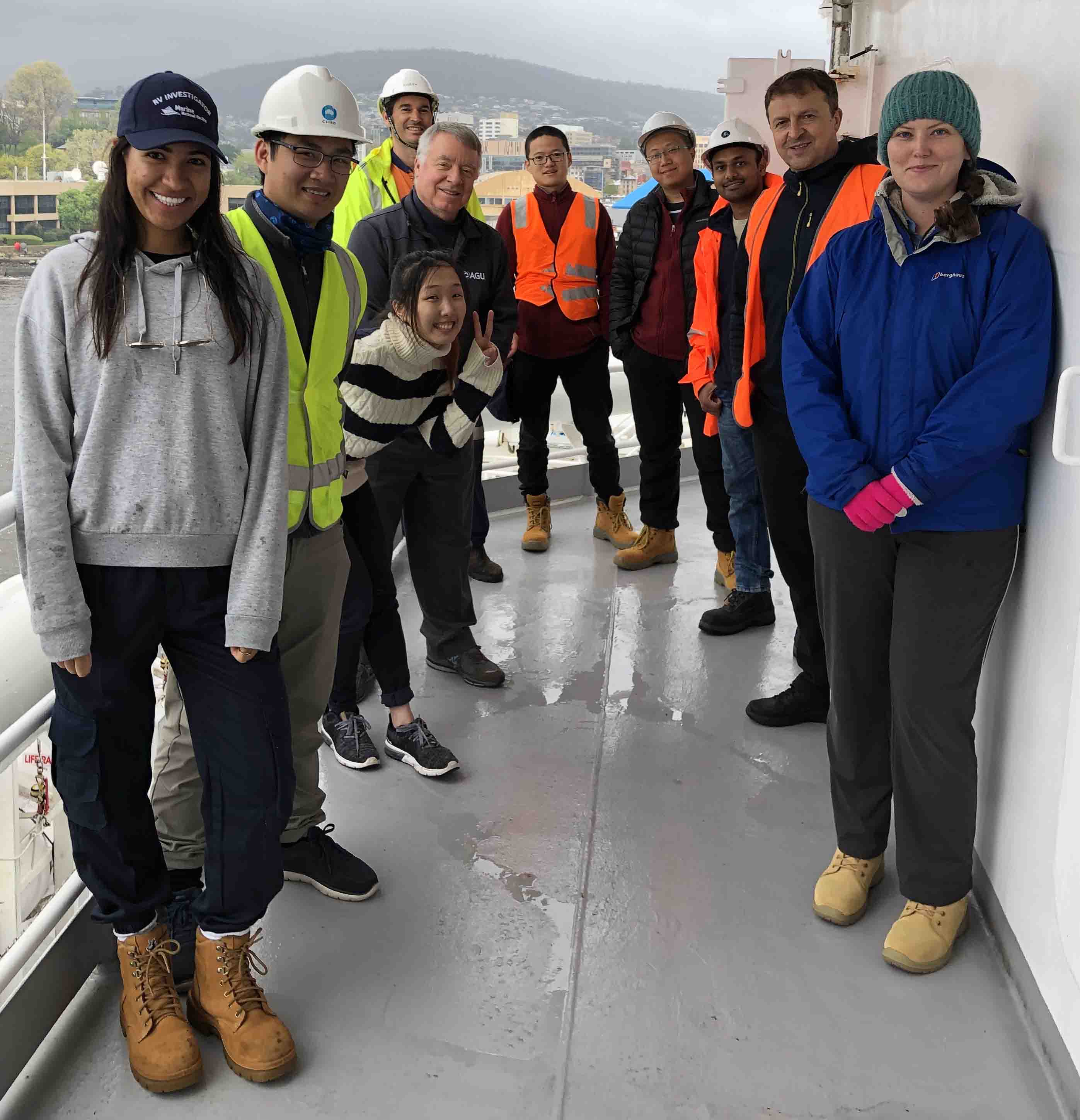
(Image, right: the shipboard science party departing Hobart on 8 October. Credit: Megan Hartog, CSIRO)
We embarked from Hobart at 1300 on Thursday 8 October to commence the 3.5-day transit to the Macquarie Island region. During the transit, we acquired multibeam bathymetry/backscatter, sub-bottom profiler, magnetics, and gravity data continuously. Spring weather in the Roaring Forties and Furious Fifties has been challenging so far, with two +40-knot blows impeding development of our sea legs. We arrived at our study area late on 11 October and commenced our search for suitable OBS deployment sites.
This research is supported by a grant of sea-time on RV Investigator from CSIRO’s Marine National Facility, by Australian Research Council grant DP200101854, by Natural Environmental Research Council (UK) grant NE/T000082/1, the Australian National Seismic Imaging Resource/AuScope, the Australian National University, the University of Cambridge, the University of Tasmania, and the California Institute of Technology.
Institute for Marine and Antarctic Studies
Phone: +61 3 6226 6379
ABN: 30 764 374 782 CRICOS Provider Code: 00586B